Wednesday, 16 – Thursday, 17, September 2015
Zion National Park
For those of you who have been to both Bryce and Zion, you will recall the distance between the two is only about 70 miles. But what a difference between the two parks. As you will recall, at Bryce one descends into the canyon floor to view its wonders. At Zion, one arrives directly on the canyon floor with its magnificent canyon walls towering high overhead. Bryce is basically a desert while Zion has the feel of semi-tropics. However, both are magnificent in their own right.
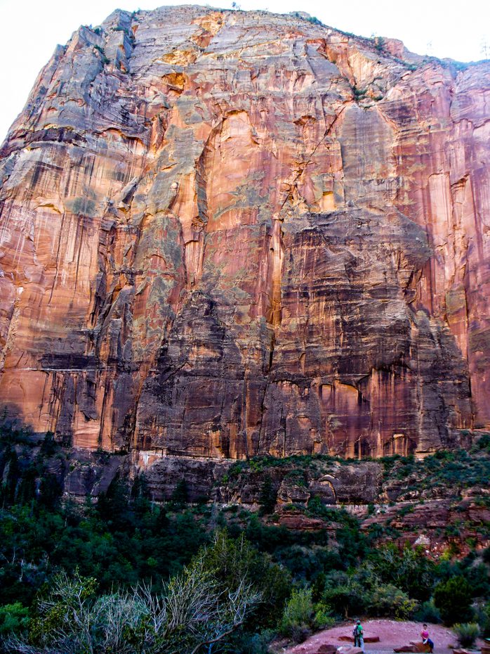
The magnificence of Zion is it towering canyon walls, most over 1000 feet high. The small Virgin river runs through the canyon. When compared to other mighty rivers in the US (such as the Mississippi, the Columbia and the Missouri) the Virgin pales into insignificance. However, over millions of years, this tiny river has carved these 1000 foot canyon walls.
Zion’s adaptation to the throng of tourists perhaps heralds the way other parks will run in the near future. To enter and view the majority of the park wonders, one must board a bus which takes you to various stops in the central park boundary. No private motorized vehicles are allowed. In this way, traffic issues are eliminated and crowd control is better managed.
For the adventurer, the two of the more attractive hikes at Zion are The Narrows and Angel’s Landing.
The Narrows is located at the end of the main canyon where the Virgin river enters the more accessible part of the canyon. However, there is a wonderful hike up-river that takes the hiker into the greater depths of the canyon. This hike (if one so desires) can take two days, all the time walking only in the river itself. There is no other trail! At times, the canyon walls are no more than ten feet from each other, towering 1000 feet above. However, this hike can be extremely dangerous. Many have lost their lives do to flash floods, fed by rain runoff many miles from Zion. The day before we arrived at Zion there had been major flash flooding in the Zion area. Twenty five people lost their lives within a five-mile radius of Zion, all resulting from flash floods. We had hoped to hike up the Narrows a mile or so this time, but it was closed.
Angel’s Landing is completely different. Also classified by the park as “strenuous”, one hikes up a trail cut into the walls of one of the faces of the canyon wall. The first part of the hike is relatively easy as the park service has paved it. Arriving at the top of this portion, one wonders what makes it so difficult. Then realization sets in. Looking to the next two portions, one sees the terror that waits. On these portions, you are required to climb almost sheer faces of the cliff often using chain holds to prevent falls of over 1000 feet on either side of the path. This is indeed very scary. However, this trail is so magnificent, it is designated as a National Historic Landmark! Meriam and I made this hike when we visited Zion seven years ago. With the wind and rain of the previous day (plus being seven years older) we decided to forgo this exhilarating hike this year. However, we have included some of the photographs here we took on the previous hike.
As we left Zion, we took as 2 ½ mile hike just at the eastern entrance to Zion. This hike was relatively easy but revealed a look at Zion that is hard to make otherwise. It overlooks the entrance to the park as one descends on the road leading in.
As a photographer, one soon discovers how difficult it is to capture the true magnificence of towering cliffs and valleys. The major problem is one of perspective. While the eye (and brain) can view and comprehend the scenes when there, viewing a photograph does not give the same experience. They are just too big, massive and overwhelming. Both here at Zion and Bryce (as well as several subsequent posts) we hope we have transcended this issue somewhat.
Lastly we would like to emphasize the colors. The various reds, creams (and other associated colors) are very vivid, particularly early in the morning. Again, as a photographer, one soon learns the best photographs are taken in the early morning or late afternoon. We usually chose the early morning (being early risers.) This provided us another benefit of fewer tourists.
We took the following five photographs in 2008 when we first visited Zion. You will note we look a few years young (and at least for me a few pounds lighter.) We included them here to give you and idea of what the hike to Angel’s Landing was like. This first picture is taken of Angel’s Landing from ground level. In fact, if you look closely, you can see Meriam in the bright red shirt in the lower right.
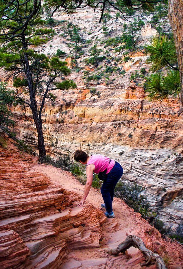
Here Meriam is making her way along the “trail” as we ascend to the top. While it is hard to see, immediately to her right is a 1000 foot drop off!
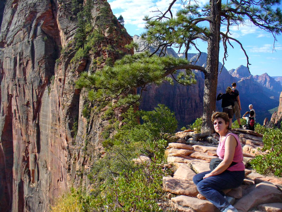
MB resting no more than 3 feet from the edge.

The chain is used when there is a 1000 foot drop off on both sides!

Remember the first photograph with Meriam at the foot of Angel’s Landing? Here she is looking down at that location 1000 feet below. If you look closely, the very small white spec is one of the tandem park shuttle buses.


In the text we mentioned The Narrows was closed!

Along the hike to The Narrows. Unbelievable beauty.

Part of the “hanging gardens” on a cliff side.

This is the beginning of The Narrows. Note the Virgin River. It was about 2 feet deep just two days after major flooding. One can hike (when not closed) more than 10 miles up stream from here.

Incredible color.

If you look closely here in the lower right, you can spot several hikers along one of the trails we took. This hike was MUCH easier than Angel’s Landing or The Narrows.


Earlier in the year, this small waterfall is often a raging torrent.

As we were leaving the Park, we spotted what looked like a small rock on top of a peak hundreds of feet above us. On closer inspection, this “rock” unfolded a wing. I used a telephoto lens here to capture this shot. This was a VERY large bird. We think it was one of the few California Condors (but we are not positive, it could have been a very large vulture.)

As we began our last hike in Zion (just outside the east entrance), we had a couple of Desert Bighorn Sheep tell us to make sure our footing was sound!

The east entrance to Zion goes through this small tunnel made back in the early 1930s. Today’s vehicles must now go through single file each way.


If you look closely, you can spot the trail running along the middle left hand portion of this photograph. This hike was fairly easy. There were only one or two places which caused the hair on the back of our neck to rise.

A view of the entrance of Zion from the east (after exiting the tunnel.) We took this from the top of our hike. Note the road below as it snakes along towards the main part of the park.

As always seems to be the case, Meriam is drawn to the edge of high cliffs!

The sculpture of this hill is most fascinating, caused by wind erosion. No surprise, it is called Checkerboard Mountain.