(July 29, 2018) Our 903-mile trek from Prince Rupert to Skagway in Alaska, we yet again traversed the isolated, quiet beauty of the Cassiar Highway. Along the way, we encountered 5 black bears, 1 grizzly bear, two moose (one which was too close for comfort), and a fox – all of them as we drove along the highway. Think what was watching us from the depths of the forest!
As the Cassiar connected to the Alaska Highway, we detoured about 20 miles to visit Watson Lake, home of the Sign Post Forest. As some of you might recall, we visited Watson Lake four years ago and placed a sign for Jefferson in the Forest. While there this time, we confirmed our Jefferson sign still declares our city’s presence (Jefferson, TX 3062 miles).
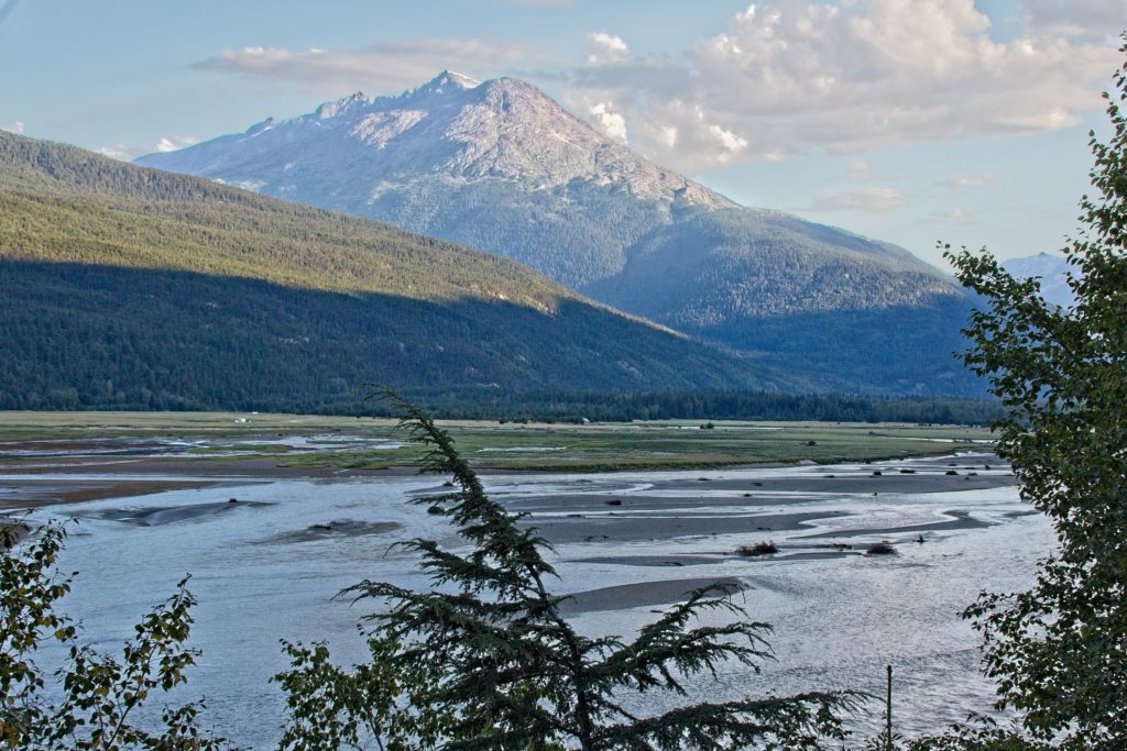
On the way to Skagway, we passed through one of the more scenic mountainous passes we have encountered on our travels.
As we are sure most of you know, Skagway has become inexorably linked with the Klondike Gold Rush of 1897-1898. What we did not know was of a sister town named Dyea which had a much older history, serving as a home to a tribe of Tlingit. I say “had” since Dyea no longer exists (except as a National Park Service site)! During the gold rush, it was a city of 10,000, set up among the spruce and hemlock forest at the edge of a long tidal flat, connected by two, mile-long wharves to the ships in the inlet.
Rather stay in the hustle and bustle of Skagway, we opted to stay our two nights in Dyea One morning, we took a 4-mile hike to the old site of Dyea. While there we met a gentleman who has trekked the “Chilkoot Trail” more than 15 times (more on the Chilkoot Trail later)!
As gold seekers from around the world began their relentless rush for gold in the Klondike, they had three choices to make their way to Dawson in the Yukon. The easiest (but longest and most expensive) was by boat which took them on a sea voyage to the far northern part of Alaska, where they then traveled the Yukon River to Dawson. The other two routes were by land. One starting in Skagway and the other just 9 miles away in Dyea. Skagway seekers took the White Pass route and Dyea seekers took the Chilkoot route. The Chilkoot route was shorter but require traversing much higher mountains while the White Pass route was longer but required trudging through miles of mud. One route was known as Hell and the other Damnation!
The Chilkoot Trail is now part of the US Park Service and one has to make reservations to hike it. It is a 33-mile trek (taking 6-8 days) through history where one comes face-to-face with hundreds of relics discarded by the gold seekers as they made their way north. It is known as the world’s longest outdoor museum with 17 miles in the US and 16 miles in Canada. During the two years of the gold rush, over 100,000 people attempted this trek, with “only” 40,000 making it. One chilling side note: At the summit of the Chilkoot Pass (see a photograph below), the Royal Canadian Mounted Police met the seekers and required them to possess 2000 lbs of food and supplies before they could continue their way into Canada. This requirement was to make sure they had enough to survive the winter. However, this often required the seekers to make the climb more than 40 times, each time delivering part of their load! Once the gold seekers reached the summit of the Chilkoot Pass, they now had only 600 miles more to go! Another side note: Once these seekers reached Dawson, they would find a bustling city already established by earlier gold seekers and no gold claims to be had.
Skagway is a quaint, quiet tourist town of about 1500 people – at least until the cruise ships dock and unload their 10,000+ passengers. There were four ships in port on the days we were there. The National Park Service maintains a significant presence in Skagway, owning and preserving 15 historic buildings. While Skagway has a certain charm as a tourist town, we were more drawn to the solitude of Dyea.
Back in Dyea, we decided to have a beer at the only restaurant there. As it often turns out when we slow down and engage with the locals, the history of the places come alive. The proprietor of the place remembered talking with his granddad who lived and played in Dyea at the age of 4 when the gold rush transpired. They also said President Trump has connections to Dyea as one of his ancestors lived there.
The passing of Dyea and ascendance of Skagway is attributed to several factors. Skagway has a natural deep port where large ships can dock while Dyea only has a tidal plain access to the ocean and the railroad chose to Skagway and not Dyea.
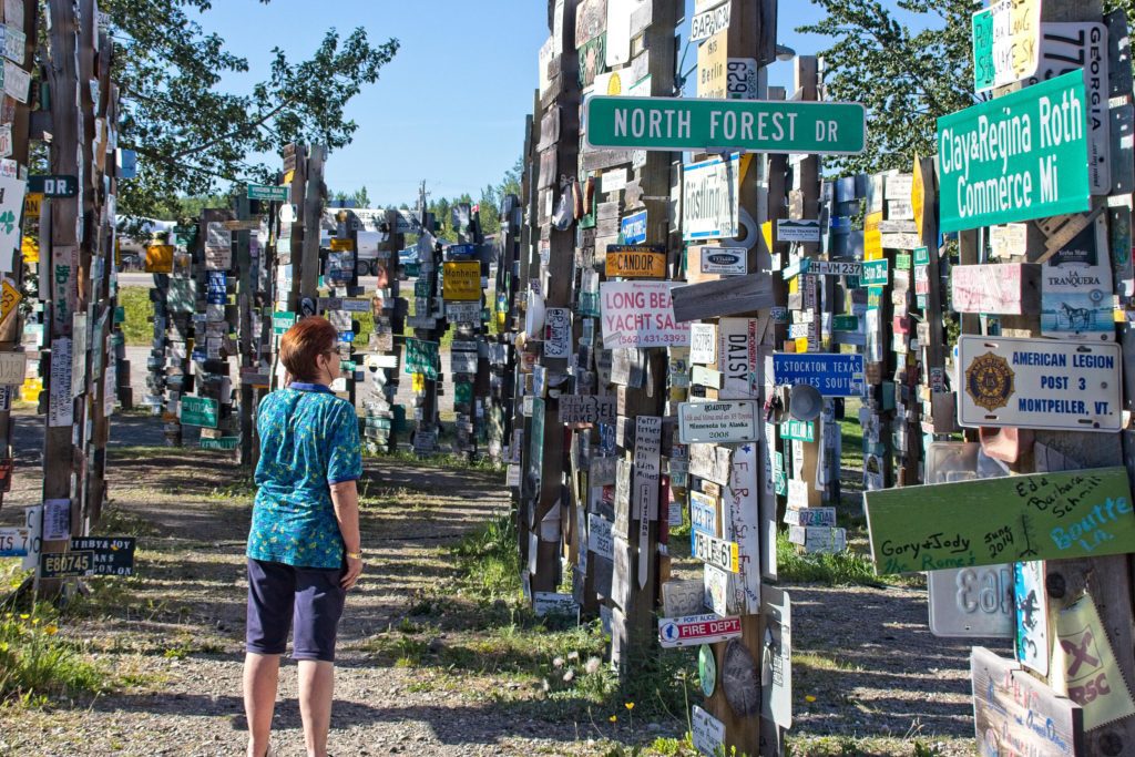
The Sign Post Forest at Watson Lake. As of September 2017, there were 85,736 signs from all over the world! What a marketing idea for a town…and it cost the town nothing since all the signs are brought in, and hung, by the visitors.

While MB and I were trying to locate our “Jefferson” sign, I took this photograph. The shadow is Meriam. Note the Jefferson sign on the row in between her and me (green, 2/3 way up on the third post from the right). If says “Jefferson, Texas 3,062 miles”.

A yearly history in the growth of signposts as the word gets out!

“Just” another beautiful scene along the road from Watson Lake to Skagway. Check out the thin layer of clouds between the two mountains. BTW, THIS is why we boondock!
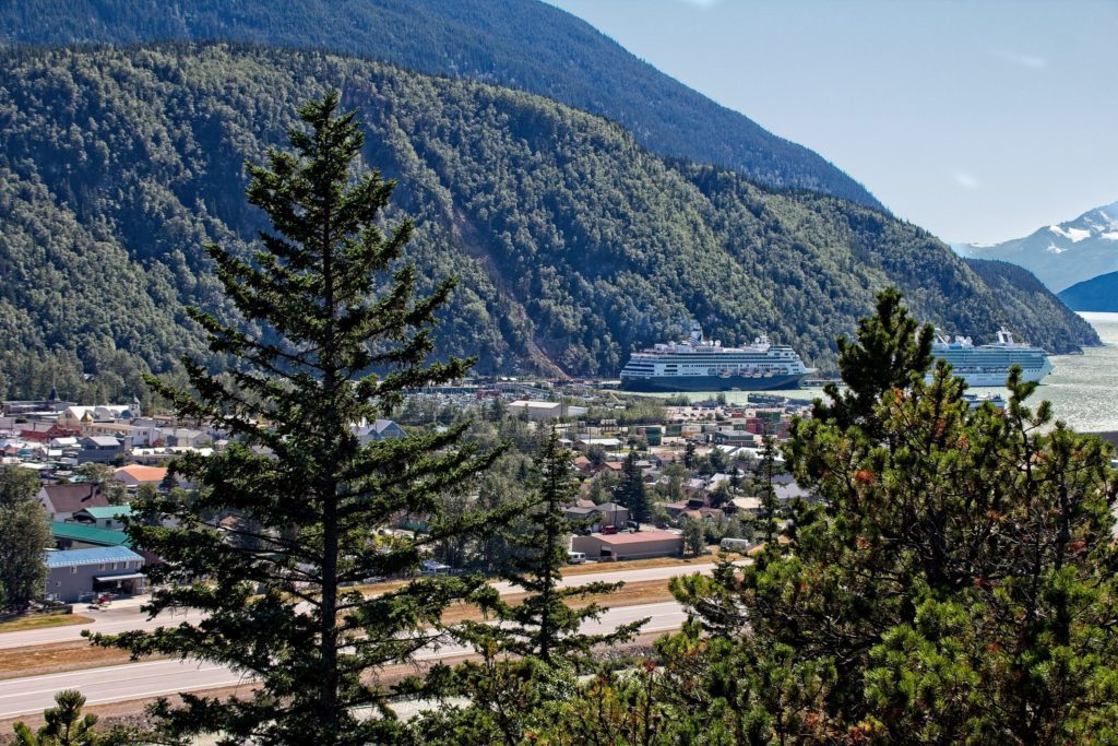
The town of Skagway. Notice the outstanding natural harbor which enables the largest cruise ships to dock right in town.

The sun rising over a couple of Skagway’s many historical buildings.

“All Aboard” for Skagway’s most popular tourist attraction. Thousands from the cruise ships every year take a scenic ride into the mountains on this historic White Pass narrow gauge train.
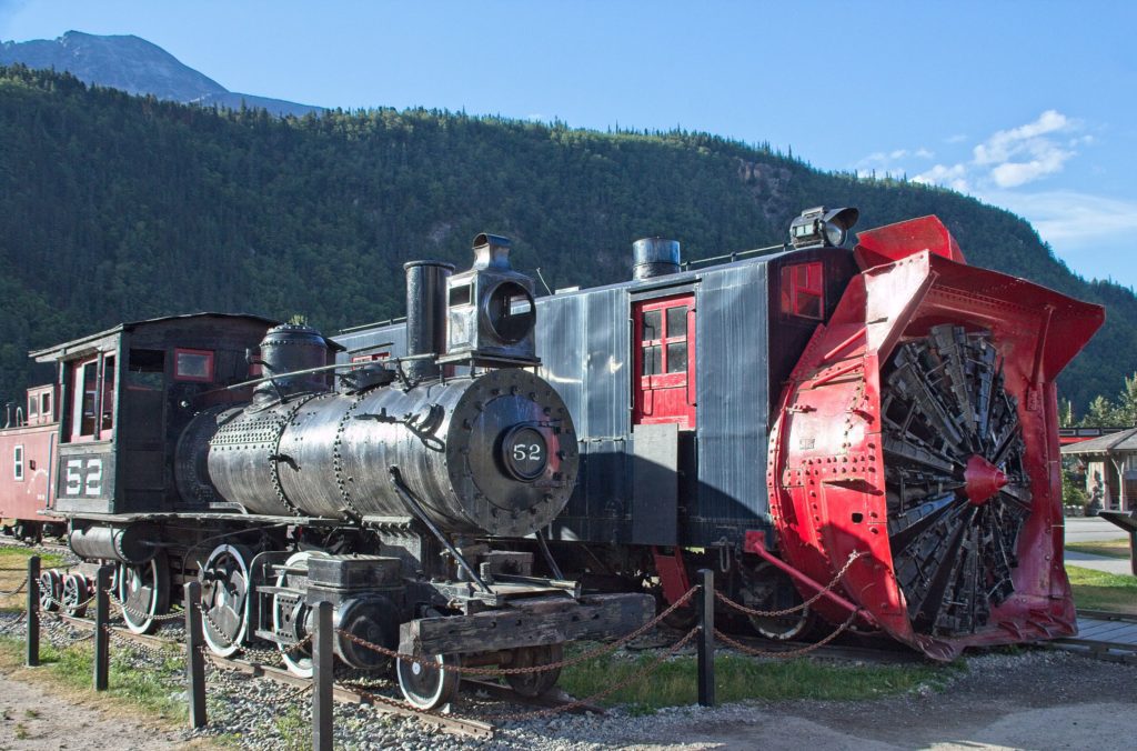
Two of the vintage engines from the White Pass Railroad’s earlier days. The engine of the right is used to clear snow from the tracks.
A view in the distance of where the old town of Dyea used to stand. Mile-long docks used to connect the town to the seagoing vessels (further off to the left of this photograph).

MB stands at the site where the town wharf used to stand. The previous photograph was taken from the hill in the distance (directly above her head).
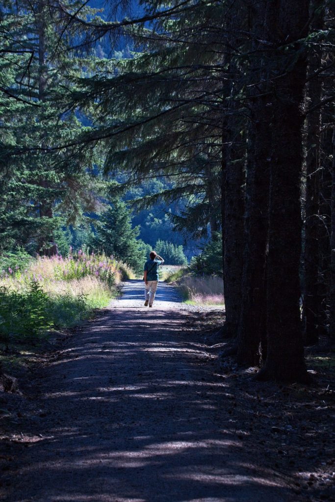
The Park Service maintains a series of paths allowing one to “meander” through the streets of Dyea.
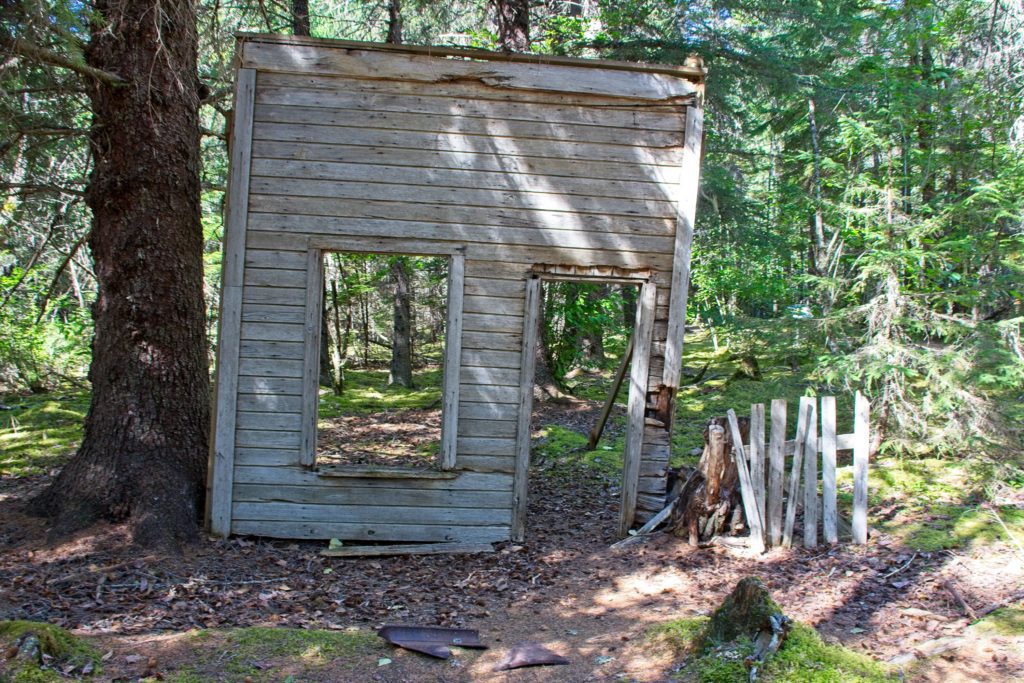
The sole remaining “building” from Dyea. This is the only structure the Park Service maintains. They have chosen to let nature reclaim all else. But one can still feel “the spirit” of the town.
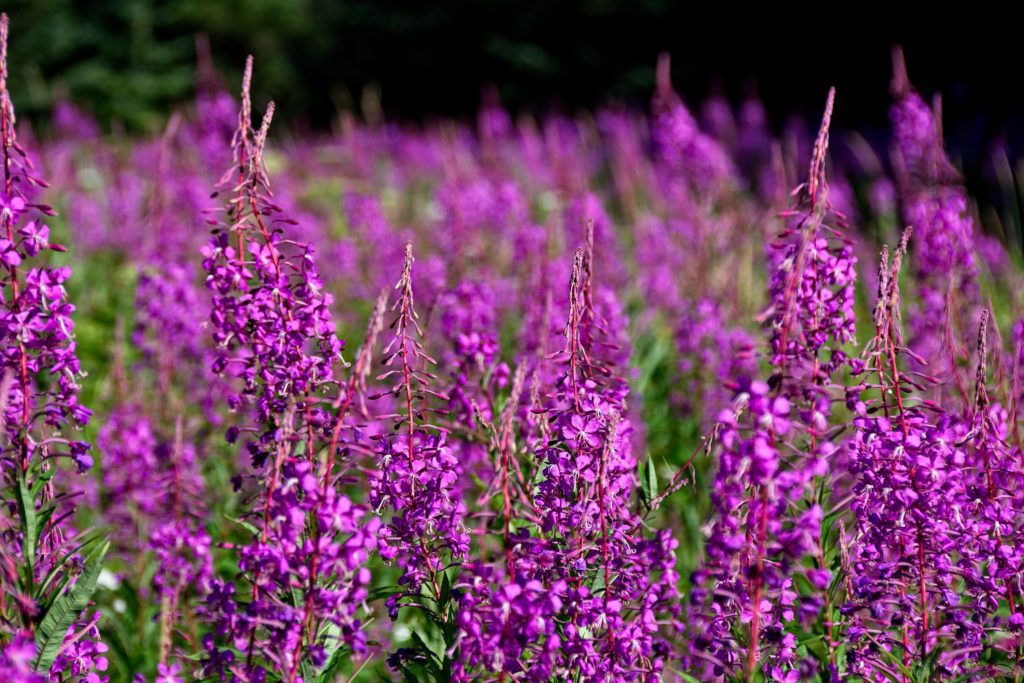
The ubiquitous “fireweed”. This flower is located all over the northern portions of Alaska, the Yukon, and British Columbia. Fields and fields can be seen, much like the bluebonnets in Central Texas.
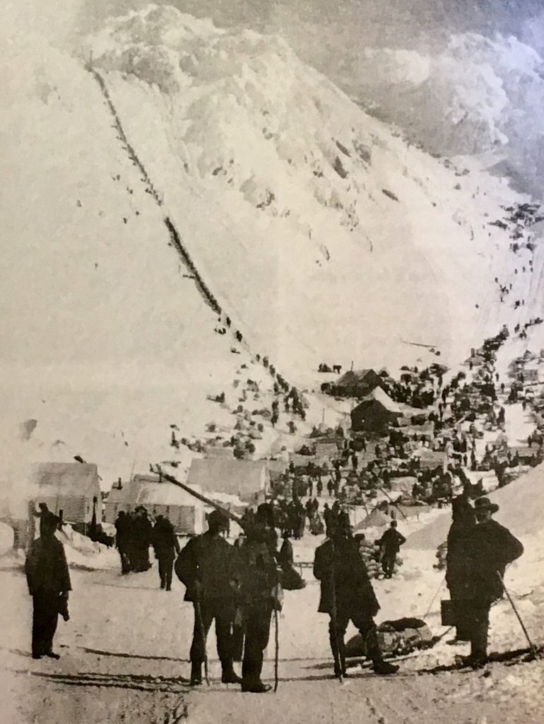
No trip to Skagway is complete without experiencing the emotions this photograph evokes. This is the infamous “Skilkoot Passage”. As mentioned previously, 100,000 souls attempted this climb with “only” 40,000 completing it. Its located 16 miles from the town of Dyea. You will also recall, because of Canadian requirements, most had to make the climb some 40 times!
AmyMakes me miss my trips to Alaska. Love the fireweed.
HaroldAmy, we can empathize with you. This is almost certainly our last trip to Alaska.
Diana WallaOMG! 40 times? People were a lot more determined in those olden times!!
Thanks for another beautiful story … why haven’t you written a book? Diana
HaroldAnd after the 40 trips, they had 600 more miles to go! Regarding a book, I am looking for a publisher…NOT!
SamI think your commentary keeps getting better and better. Great photos. We are looking forward to seeing the sign posts one day.
HaroldThanks, Sam. You guys home from your trip yet? When you come up, maybe you can get the city to give you an official sign. We tried twice and then gave up!
maoIs it Chillkoot or Skilkoot? Great photos and stories. Thanks for sharing.
HaroldMAO, everything we saw had it spelled “Chilkoot”.
maoIs it Chilkoot or Skilkoot?? Beautiful pictures and story. I remember the story about the requirement to carry a ton of supplies. Wish we had seen that part of Alaska. How far north are you planning to go?